
Short Answer
Cloud formations are among the oldest and most reliable weather instruments a sailor has. Unlike barometers or GRIB files, clouds are always visible, update in real time, and require no power. For recreational sailors, learning to read the sky is not a nostalgic skill; it is a practical, decision-critical part of passage planning and safe seamanship. An independent sailing reference platform can structure this knowledge so that a sailor can move from simply recognizing cloud types to anticipating frontal changes, squalls, and clearing trends with confidence.
Main Explanation
What it is
Reading cloud formations for sailing weather is the systematic observation and interpretation of cloud type, height, sequence, color, and movement to anticipate changes in wind, visibility, and precipitation. In the context of an independent sailing reference and tools platform, it is a structured guide that consolidates cloud classification, frontal cloud sequences, and decision rules without being tied to a specific boat brand, sailing school, or equipment manufacturer. The goal is to give sailors a reliable, repeatable method for using the sky as a real-time weather instrument, especially when official forecasts are unavailable, outdated, or too coarse for local conditions.
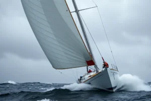
Offshore, the sky is the primary instrument. As noted in field notes from VAKA, there is no coastline to triangulate against, no harbour wall to shelter behind, and often no radio contact close enough to update the forecast. What is overhead and what is approaching from the horizon is the most current weather information available, and it arrives in real time.
Why it matters
Recreational sailors face a flood of weather information: GRIB files, weather apps, VHF broadcasts, and online forums. This can lead to information overload and conflicting advice. Many resources are outdated, assume local knowledge, or are written for professional mariners. The stakes of a poor decision at sea are high: an unexpected squall can knock down a boat, a misread frontal passage can leave a crew beating into a strengthening headwind, and a missed clearing trend can mean an unnecessary night at sea.
Cloud reading cuts through the noise. It provides a direct, local, and immediate source of information that does not depend on connectivity or battery power. High clouds such as cirrus and cirrostratus are often the first indicators of an approaching warm front, giving 24 to 48 hours of warning. A towering cumulonimbus, by contrast, may give only minutes of warning but is unmistakable if you know what to look for. An independent reference platform helps sailors build this skill systematically, with clear explanations and practical checklists, rather than relying on scattered forum posts or manufacturer manuals that rarely cover meteorology in depth.
How it works
A well-structured cloud-reading reference for sailors typically covers four areas: cloud classification, frontal sequences, cloud color and rain intensity, and dangerous cloud management. The platform may include visual guides, decision trees, and printable checklists.
- Cloud classification: High clouds (cirrus, cirrostratus, cirrocumulus) above about 6,000 m are made of ice crystals and signal change. Mid-level clouds (altostratus, altocumulus) often thicken ahead of a front. Low clouds (stratus, stratocumulus, nimbostratus) bring drizzle, poor visibility, or steady rain. Vertical clouds (cumulus, cumulonimbus) indicate instability and possible squalls.
- Frontal sequence: A classic warm front approach follows a recognizable order: cirrus, then cirrostratus, then altostratus, then nimbostratus with rain. A cold front often brings a sharper band of cumulus or cumulonimbus, followed by clearing and a wind shift.
- Cloud color and rain intensity: Darker, more uniform cloud bases generally mean heavier rain. A greenish tint under a cumulonimbus can indicate hail. Bright white tops on cumulus suggest building convection.
- Cumulonimbus management: The cumulonimbus at sea is the most dangerous cloud for a small boat. It can produce violent downdrafts, sudden wind shifts, lightning, hail, and waterspouts. The correct response is early recognition, reefing before it arrives, and avoiding the most active cell if possible.
In practice, a sailor uses these tools by observing the sky at regular intervals, comparing what they see with the expected frontal sequence, and cross-checking with barometric pressure and wind direction. The platform may offer decision-support prompts such as: ‘If cirrus is thickening and the barometer is falling, expect a warm front within 24 hours; consider shortening sail or altering course.’
How to do it
Imagine planning a 60-nautical-mile coastal passage. The night before, you check the official marine forecast and note a weak cold front expected to pass through the area late the next afternoon. At departure, the sky is clear but you notice a few high, wispy cirrus clouds to the west. You log this and continue.
- Before departure: Review the forecast and identify the expected frontal timing. Note the current barometric pressure and wind direction.
- At the dock: Look at the whole sky, not just the horizon. Identify any high clouds and their direction of movement. Cirrus moving from the west often precedes a change.
- Underway, first two hours: Watch for cirrus thickening into a milky cirrostratus veil. If the sun or moon develops a halo, that is a strong sign of an approaching warm front or the leading edge of a low-pressure system.
- Midday: If altostratus replaces the cirrostratus and the sky turns gray, expect rain within several hours. Begin thinking about reefing points and whether to duck into a harbour.
- Afternoon: If cumulus clouds start building vertically and develop dark, flat bases, a cold front or squall line may be near. Monitor for anvil-shaped tops, which indicate cumulonimbus. Reef early, secure loose gear, and note the wind direction shift.
- Post-frontal: After the front passes, the wind often veers, the temperature drops, and the sky clears from the west. This is the post-frontal window: good visibility and steadier wind, but possibly stronger gusts.
Throughout the passage, you cross-check cloud observations with barometer readings and the official forecast. If the clouds and the forecast disagree, trust the clouds for immediate local conditions but use the forecast for the bigger picture.
When not to do it
Cloud reading is a powerful supplement, but it has clear limits. It should not be the sole basis for major routing decisions on an ocean crossing, where professional weather routers and satellite data provide a broader view. It cannot replace a certified marine surveyor when evaluating a boat’s structural capability for heavy weather. It is not a substitute for formal training in heavy weather seamanship, such as a recognized safety at sea course. And it is not a real-time data feed: a cloud reference guide tells you what a cloud means, but it does not tell you the exact wind speed, wave height, or lightning strike probability at your position. For those, you need official forecasts, radar, and on-board instruments.
Visual
The table below compares an independent cloud-reading reference platform with other common sailing information sources.
| Source | Strengths | Limitations | Best For |
|---|---|---|---|
| Independent cloud-reading reference platform | Structured, unbiased, practical; covers frontal sequences and decision rules; works offline | Requires practice to apply at sea; not a real-time data source | Building a repeatable cloud-reading skill for coastal and offshore passages |
| Traditional textbooks | Comprehensive meteorology; good theory | Can be dense, outdated, or not sailing-specific | Deep background study |
| Manufacturer manuals | Specific to your boat’s systems | Rarely cover weather interpretation | Boat operation and maintenance |
| Sailing school courses | Hands-on, instructor feedback | Time and cost; may not cover cloud reading in depth | Structured learning and certification |
| Online forums | Real-world anecdotes, quick answers | Conflicting advice, no quality control | Supplemental tips, not primary learning |
| GRIB files and weather apps | Quantitative wind, wave, pressure data | Model uncertainty; no local cloud detail; requires connectivity | Route planning and forecast cross-checking |
Common Mistakes
Over-reliance on a single cloud type
Many sailors learn to recognize cumulonimbus and then ignore the subtler high clouds. Consequence: they miss the 24-hour warning of a warm front and get caught by deteriorating conditions. Correct approach: learn the full frontal sequence, not just the dramatic clouds.
Ignoring weather updates after departure
A forecast checked at the dock is not a forecast for the whole passage. Consequence: a front may arrive earlier or stronger than predicted, and the sailor is unprepared. Correct approach: update the forecast via VHF, satellite, or SSB when possible, and use cloud observations to fill the gaps.
Misidentifying cloud types due to lack of practice
Cirrostratus and altostratus can look similar, but the halo test helps: a halo around the sun or moon indicates cirrostratus. Consequence: misjudging the timing of an approaching front. Correct approach: practice with a cloud chart and compare your observations with official reports.
Confusing reference material with real-time data
A cloud guide tells you what a cloud means, but it does not tell you the current wind speed at your location. Consequence: a sailor may assume a cloud pattern guarantees a certain wind shift and make a routing decision without checking instruments. Correct approach: always cross-check cloud observations with barometer, wind instruments, and official forecasts.
Underestimating cumulonimbus
Some sailors think a thunderstorm is just heavy rain. Consequence: a cumulonimbus can produce 40-knot downdrafts, lightning, and sudden wind shifts that can capsize a small boat. Correct approach: treat any cumulonimbus as a hazard; reef early, avoid the cell if possible, and secure the crew.
Using generic checklists without adapting to local conditions
A cloud sequence that works in the North Atlantic may not apply in the tropics, where convection is more diurnal and fronts are less defined. Consequence: misapplying a template can lead to false confidence. Correct approach: adapt the reference to your sailing area, season, and boat type, and validate with local knowledge.
Safety Note
Cloud reading is a decision-support skill, not a safety system. It must fit into a broader safety framework that includes proper training, physical checks, and redundant navigation. Always cross-check critical weather, tide, and navigation data with official sources such as national weather services, coast guard broadcasts, and local harbour authorities. Never use a tablet or phone as your only navigation tool; carry paper charts and a handheld compass as backup. Take a certified safety at sea course that covers heavy weather, man overboard, and emergency procedures. Follow the International Regulations for Preventing Collisions at Sea (COLREGS) and all local maritime regulations. Before departure, physically inspect your boat’s rigging, hatches, bilge pumps, and safety equipment. A cloud reference platform can help you anticipate weather, but it cannot reef your sails, steer your boat, or call for help. Human judgment, trained crew, and a well-found boat remain the final safety net.
FAQ
How far in advance can clouds predict weather?
High clouds like cirrus can signal a warm front 24 to 48 hours ahead. Cumulonimbus, by contrast, may give only minutes of warning before a squall hits.
What is the most dangerous cloud for sailors?
Cumulonimbus is the most dangerous because it can produce violent downdrafts, sudden wind shifts, lightning, hail, and waterspouts with little warning.
Can I rely on cloud reading alone for passage planning?
No. Cloud reading should complement official forecasts, GRIB data, and local knowledge. It is a real-time local supplement, not a replacement for broader weather information.
How do I distinguish cirrostratus from altostratus?
Cirrostratus is thin enough to produce a halo around the sun or moon. Altostratus is thicker and grayer, often obscuring the sun without a halo.
Do cloud colors really indicate rain intensity?
Yes. Darker, more uniform cloud bases generally mean heavier rain. A greenish tint under a cumulonimbus can indicate hail.




















Leave a Reply